

- City govt essential for planned development of Chattogram: CCC administrator |
- Asian Stocks Slump After US Tech Rout Amid AI Jitters |
- Free Concert Featuring James and Seven Bands Set for Manik Mia Avenue |
- Garment factories reopen as workers return to work in Savar-Ashulia |
- Trump confirms new US strikes on Iran’s Qeshm island |
El Niño Surges Into ‘Very Strong’ Territory, With December Peak and a Wet Winter Ahead for California
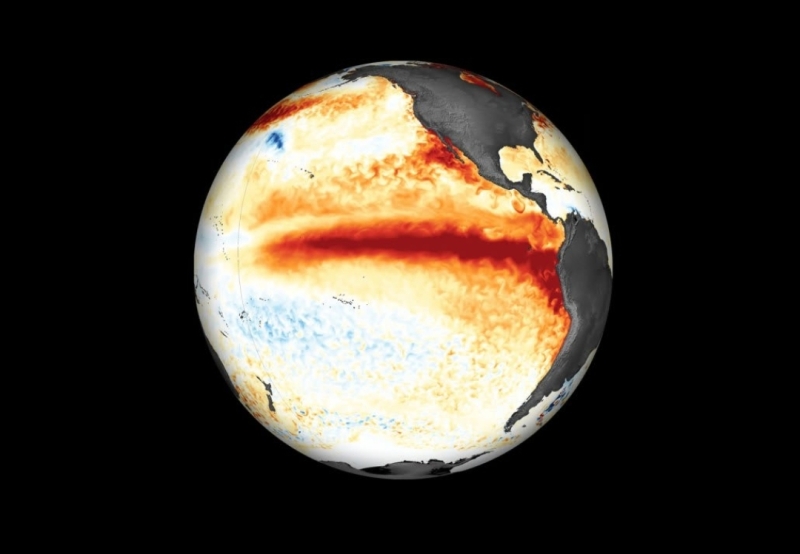
Image: Collected
El Niño has strengthened into the “very strong” category, with Pacific Ocean temperatures expected to peak in December and potentially make this one of the most powerful events on record. The World Meteorological Organization (WMO) forecasts sea-surface temperatures in the tropical Pacific to reach about 3.8°C above average from November 2026 through January 2027.
A Historic Warming Event
Using NOAA’s newer Relative Oceanic Niño Index (RONI), which removes background warming across tropical oceans, the August–October average reached +2.0°C—meeting the “very strong” threshold. The conventional Oceanic Niño Index had already reached +2.2°C for July–September and +2.5°C for August–October.
NOAA’s Climate Prediction Center expects the event to remain strong to very strong through January–March 2027. Its outlook gives a 70% chance that November–January will become a historic El Niño—stronger than any recorded since 1950.
“This is literally off the monitoring charts that we have used for the past four decades,” WMO Secretary-General Celeste Saulo said. She said El Niño would likely peak toward the end of 2026, while its effects would continue well beyond that.
California Braces for a Wet Winter
California faces an unusually wet outlook. All 51 runs of the European Centre for Medium-Range Weather Forecasts’ seasonal model, released November 5, predict above-normal rainfall across the San Francisco area from December through March.
The model’s average forecast is about 26 inches of rain—nearly double the normal amount. January is projected to be the wettest month, with more than 8 inches expected.
Unusually warm coastal waters could intensify the risk. The forecast expects ocean temperatures off California to run 10–13°F above normal in December, putting water near San Francisco close to 67°F rather than the usual 54°F. Warmer water can provide incoming storms with additional moisture.
Global Impacts
The WMO outlook warns of drier conditions in southern Africa, rainfall deficits in Southeast Asia, and elevated drought risk in Central America and the Amazon. Saulo stressed that a powerful El Niño does not automatically lead to humanitarian disaster, but said decisive action is needed to protect vulnerable communities.
NOAA’s broader winter outlook also favors wetter-than-average conditions across much of the southern United States, from California to Florida, while northern areas are expected to be warmer than average.
What Comes Next
Forecasters will watch whether Pacific temperatures peak in December as expected and whether the wet signal for California materializes into repeated storm systems. While seasonal forecasts show unusually high confidence, NOAA cautions that a stronger El Niño increases the likelihood of expected impacts but does not guarantee them.